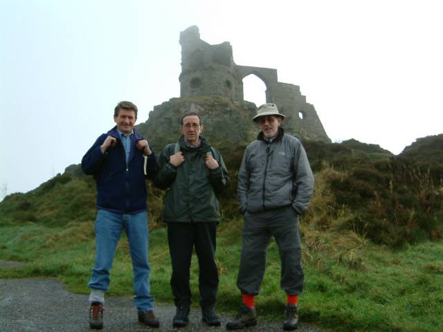
The start at Mow Cop
posted by Frank Smith @ 1:03 pm
![]()
This is a blog which will record a series of walks on the Staffordshire Way made by myself and a couple of friends. It will give us something to do during an English winter and help to keep fitter than we would be by sitting watching the tele.

This first section was from Mow Cop to a car park at the northern end of Rudyard Lake undertaken on Sunday, 5th December, 2004. We took two cars. I was in one with Conrad Joseph and Peter Green was in the other with Keith 'Coddy' Walker, an appropriate name, (walker not coddy). We dropped Pete's car at Rudyard and piled into Conrad's car which he drove to a misty Mow Cop. Unfortunately Conrad isn't able to do the walk so he then left for home. We really appreciated his initial assistance as back up.
The walk started at 11am. We got off to a slow start because we couldn't find the official path but eventually joined it below Mow Man, a pillar of rock left by quarry workers who removed the surrounding rock. The first mile or so was on road which none of us particularly enjoy, this stretch being narrow, in places a little too narrow in view of the traffic, but it was quiet enough at that time. We eventually got onto Edge Hill having slowed down to watch some offroad type vehicles competing on a hillside track close to the road.
I don't think that I am going to cover the walk inch by inch. I have other things to do. The weather started off misty and cold, after all it is December, but we quickly warmed up and the sun poked its head out from time to time and the visibility improved. After a couple of miles we were so warm that we each took a layer of clothing off and I carried my 'Tilley' for a while in my hand.
We travelled along a disused railway for a while and then into a couple of fields leading through a farm yard. This was the first of a few very muddy sections and I managed to get a load of muddy water in my left boot. We had been on the level for quite a while but after this we started to climb up to 'The Cloud' across typical moorland having had our sarnies and coffee just inside (I think) Cloud Plantation. (I am writing this from memory as Pete has the Staffordshire Way book). On arrival at the summit some friendly walkers took our photograph next to the triangulation point. From here we could see where we had come from but couldn't see the Jodrell Bank telescope which is eight miles away, due to mist. The Cloud would be a wonderful viewing point on a clear day. As it was we still had a pretty good view and could see Rudyard Reservoir, our destination to the north east, very well. (Wonder why it's called The Cloud).
From the top we quickly dropped down to a road for a short while before turning right and through a series of fields which eventually led to an old railway track and back to Pete's car. This section was really muddy and slowed us down a lot as well being very arduous. We arrived with three inches of mud on our boots at about 4pm just as it was getting dark. That reminds me I've got to clean them before our next walk which is planned for 16th December.
According to my GPS V Cloud is 1122 feet in altitude. The walk was 11.2 miles in length. We parked the car at N 53deg 08.858' W 002 deg 05.535'. I can't see a degree sign on my keyboard. The elevation there was 377 feet. I stupidly didn't mark the elevation at Mow Cop but it is about 1020 feet if I remember rightly. On the way home I had a splitting headache and I'm sure it was dehydration that caused it so I must carry bottled water next time. I'm writing this the day after the walk. Legs aren't too bad but get the occasional twinge in the knees. Wonder how the other walkers are?
posted by Frank Smith @ 1:00 pm
0 comments
![]()
The next section of the walk was from Rudyard Lake to the Railway Station on the Churnet Valley Railway, at Basford Green. This section was walked on Thursday 16th December, 2004. Conrad again helped out with transport. We dropped my car at the station and Conrad then drove myself, Pete and Coddy to the northerly end of the lake. It was there that I realized that I was still wearing my casual shoes and that I would have to carry them in a plastic shopping bag during the walk because I didn't have room in my rucsack. Coddy kindly pointed out that I looked a bit of an idiot on a walk carrying a shopping bag and made room in his sack for them.
We started off at about 11.30am. The first part of the walk is the length of the lake's westerly side. No problems here. We walked through the grounds of a rather fine house with castelated walls, called Cliffe Park and took photos at the dam at the end of the lake. From there the walk continued alongside a stream which I led eventually to the Caldon Canal. We spotted a heron on this part of the walk. At 1pm we stopped at a bench which someone had kindly provided near to the stream and had lunch. In front of us was a road in the process of being built. It will certainly spoil the tranquility of this particular beauty spot. I recall that this was a very muddy section of walk.
I'm writing this from memory and really could do with the guide book of the walk which Pete has, to help me, but we continued on and crossed the stream over a small bridge and walked passed a council yard and then into a field where we thought we had gone too far and returned a couple of hundred yards to try and find the path only to discover that what had thrown us was that all the Staffs. Way signs we had seen so far were yellow on a white background but at this location there was one that was yellow on a black background. Anyway we retraced our steps and passed through a wood and onto (I think) City Road. I remember we had a discussion about its name, unusual in a country area. We turned left for a while and then right along a lane whose name escapes me and over the Leek Arm canal and onto the Caldon Canal. I had traveled along the Caldon and Leek Branch about twelve years ago and remember that the location where the Leek left the Caldon was a lovely place, but unfortunately is not part of the walk. There is a section of railway near to the Caldon at this point and Pete asked a passing lady whether or not it was still in use and she told him. At length. It is no longer in use.
The remainder of the walk is on the canal towpath, passing the Flint Mill at Cheddleton and on to the Churnet Valley Station where we arrived at about 3.30pm. I had walked the stretch from the Flint Mill, which is on the Stone/Leek road before with my wife, Sheila, and my son James. Sheila doesn't recall it but this does not surprise me.
The next section is from the railway station to Alton of Alton Towers fame which we will walk after Christmas.
posted by Frank Smith @ 7:00 am
0 comments
![]()
This was the third section of the walk and was made on Thursday, 28th December, 2004. The weather forecast was not too good, with a band of rain passing through. Conrad was not with us this time and we took Coddy's and Pete's cars. We left Pete's car at the car park of the Blacksmith's Arms in Alton at about 10.30am having obtained the permission of someone at the pub. Just as well because on getting back to the car we saw a notice which we hadn't seen before threatening wheel clamping to illegal parkers! Having made sure that we were all wearing our walking boots and leaving casual shoes in the Rover (Pete's) we headed off in Coddy's Golf. It rained on the way to the railway station but that was the only rain we saw of any consequence. It was cold but we soon warmed up after we started walking.
We started south on the Caldon Canal and immediately noticed that the Churnet river which runs near to it was quite high and there was flooding in some of the nearby meadows. I hadn't realized how much it had rained overnight. This stretch of the walk is accompanied by the river and the railway track. We passed a few locks and a lift bridge (see photo) and quickly reached the spot by a bridge where the Churnet meets the Caldon Canal. The river was quite swift at this point and a narrow boat would have had to have quite a large throttle opening to stem the flood. I spotted two kingfisher together on the opposite bank of the river, taking flight as we approached, the iridescent green of their feathers flashing in the sun as they flew by. (Nice bit of alliteration there).
We then approached an area which both myself and Pete had visited previously but not together. It is where the river, the canal and the railway meet in close proximity and one comes across the Black Lion pub. It looked so inviting and we were unable to resist the temptation and went inside for a quick pint of bitter. It was approaching noon and we had been walking for only an hour, but you're only young once. It was a nice pint, well kept and served. The open fire was roaring and it would have been a lovely spot to stay for a couple of hours, but we quickly downed our beer and carried on along the Caldon.
I understand that this part of the Churnet Valley is called Little Rhineland or something like that. I haven't been to the Rhine but it was a 'proper valley' as Pete called it. Deep cut and with trees either side. We were on the left hand side tow path but after a while the tow path crossed over to the other side via a bridge. I think they are called 'roving' bridges, so designed that the tow rope attached to the horse in the old days did not get tangled up with the bridge. Eventually we left the canal and crossed the Churnet flowing alongside and below the canal and then climbed (yes climbed, it had all been on the flat up until now) up a quite steep and muddy hill and down the other side. There followed an extremely muddy part of the walk, the muddiest encountered so far, until we fetched up in a little village called Kingsley where we ate our sarnies on a wall next to St Werburgh's church. (I had never heard of St Werburgh so looked it up on the internet and found that she was a devout Saxon princess, a member of the Mercian Royal household. She died in AD698). There is a St Werburgh's Church in Derby.
There then followed an even more muddy part of the walk. We again followed the river for a short time and into a farm by a pool with some swans feeding on it before turning right over a style. The path by-passed the farm yard and house and met a farm track which led uphill to a roadway. The farm house was in a great position looking over open land and the pool towards the valley beyond. I've just taken a look at the GPS track on my Mapsource CitySelect. The road is Oakamoor Road. I think that we crossed the road then (according to the track) and went down a steep downhill section meeting a couple coming up the other way. We then arrived at another road, Stoney Dale where we turned right along the tarmac road (don't like walking them) and then left towards a YHA Hostel. We passed that and then went down a steepish path in a valley passing a geocache named Ramblers Treat. I didn't go in search of it because the others didn't seem too enthusiastic (probably because they hadn't a clue what a geocache is, have you?). We then arrived at Red Road and found a very nice roadside restaurant called...Ramblers Retreat which we passed and started another climb beyond it.
It wasn't far from this spot into Alton itself. We joined the road in Alton at a pub the name of which escapes me. I had entered the Blacksmith's Arms as a waypoint so it was going to be easy to find our way back to it but Pete, embarrassingly, asked someone the way. You don't do that do you? Not when somebody with you is holding a GPS in their hand. You can't take 'em anywhere. I took a photo of Coddy outside the little circular gaol in Alton at 3.53pm. The good people of Alton had placed a nativity scene inside it. Very nice. The next section brings us to Uttoxeter and beyond which will be completed, hopefully, on Friday, 7th January just before Pete jets off to Miami for a month. Jammie beggar. By the way this section of the walk was 11 miles.
posted by Frank Smith @ 1:00 am
2 comments
![]()
This fourth section was completed on Friday, 7th January, 2005. We started from the Royal Oak public house at 10.45am and passed the Wild Duck Inn with a steep climb alongside it. It started to rain as forecast and myself and Pete stopped to don our waterproof leggings. After a few minutes the rain ceased and it remained dry for the rest of the walk. Must remember that one! We crossed a couple of muddy fields, (seem to be a feature of this walk) and then turned left along Saltersford Lane an ancient green lane so called because it was part of a network of lanes used to transport salt for preserving thoughout the country. Unusually part of the lane was paved which made a pleasant change from the mud. The lane continued for three quarters of a mile until a stile was reached. A number of fields were now traversed until the road bridge at Denstone was reached. We turned left to Quixhill Bridge where we turned right into a field and followed the Churnet for a while. At this location there were some quite impressive gates which may have been an entrance to Alton Towers.
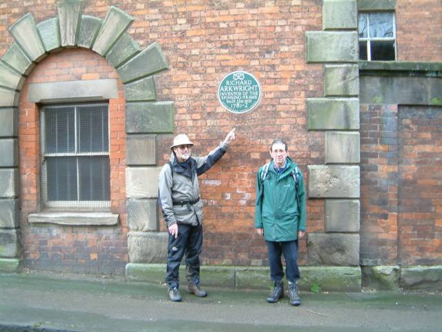
The Staffordshire Way continued south now with the strong wind right in our faces. The Churnet meanders south towards the Dove and the scenery becomes pastoral in contrast to the scenery further north. Barrowhill Wood is then passed through followed by the descent to the by-pass near to the impressive JCB World Headquarters. From here it is a short walk into the village of Rocester where two thirds of us wanted to stop to have lunch but were over ruled by Peter. We walked out of the village past Tutbury Mill built by Richard Arkwright between 1781 and 1782, and turned south again to cross farmland past the derelict Sedsall Farm and the working Eaton Dovedale Farm. We had lunch prior to this seated on a fallen elm. Somewhere between the two farms is the confluence of the Churnet and the Dove which we didn't see. Perhaps it isn't visible from the path but we would have liked to have seen it.
We were now approaching the A50 trunk road which links Derby to Stoke on Trent via Uttoxeter. We went slightly wrong here although there is an amendent in the guide. We carried straight on along an unmettled road instead of following the course of the river Dove. We crossed the noisy (and dangerous) A50 and re-discovered the path which crossed more muddy fields until the Uttoxeter National Hunt racecourse was reached. Dr Johnson's father used to run a bookstall in the town and it is said that one day young Sam refused to help his dad out on the stall. Many years later he stood in poor weather, bareheaded, in penitence for disobeying his father at the location.
We left the town by way of a path between some new houses and crossed a stile into Field Head Farm. The friendly farmer came out complaining of the strong wind and the fact that it had blown down his TV aerial. He enquired about the walk that we were on, and we then continued across his land and past his sheep to a short (muddy) lane between to hedges and back to the car parked off the road at Knightsfields Farm, at about 3.15pm. The distance according to the guide book was about 9.5 miles but the GPSV said 11.2 miles. The GPS consistently calculates a longer distance than that shown in the book. This walk although fairly level was made quite hard by the claggy mud which we encountered and the headwind we had to face for most of the walk.
posted by Frank Smith @ 1:00 am
0 comments
![]()

Coddy test driving my Tilley
posted by Frank Smith @ 12:15 pm
0 comments
![]()
The next section was walked on Thursday 10th February, 2005 and according to the book should have been about 9 miles but we did 11 according to the GPS. We started from the road outside Knightsfield Farm and straightaway got into the mud. We have all found that walking in mud can be very tiring especially when there are lots of stiles to climb. Again we were very lucky with the weather. Cold but dry and we soon got warm. The first part of the walk was much of a muchness across muddy fields and a few stiles to Hobb Lane and Marpit House Farm. We then found ourselves in Bagot's Park which is part of the ancient royal Needwood Forest and we saw remnants of this in the form of 'stagheaded' oaks which because they were not in leaf were easy to pick out. We saw a couple of fieldmice on this part of the walk and also some rabbits playing in the open. First wild life we had seen on the walk apart from birds. Whilst negotiating the fields on the way to Abbots Bromley we lost our way for a while which may account for some of the extra distance which we did. We put it down to someone turning a Staffordshire Way signpost to point the wrong way. The GPS pointed us in the right direction, however and we found our way back to the route and eventually into Abbots Bromley via Schoolhouse Lane and came out right opposite the ancient Butter Cross.
At this point it was mutually agreed by some of us, to have a pint. We decided against the Goat Inn and instead crossed the road to The Crown where we were allowed into the bar by the licensee, dirty boots and all. He even allowed us to eat our own sarnies! Brilliant.
We left after about threequarters of an hour and a pint and a half and went straight to church. This was the church of St Nicholas and we went there to view the reindeer horns which are used in the famous Horn Dance which everyone knows is held in the town on the Monday after the first Sunday after the 4th September. We left there and were now approaching Blithfield Reservoir in the vicinity of which I broke the big blade on my Swiss army knife. A new stile had been erected and nearby bits of the old one had been thrown into some undergrowth. A distinctive white and yellow Staffordshire Way marker plaque was still attached to a piece of it and I thought it would make a nice memento, tried to lever it off and snap! Blithfield reservoir is an important wildfowl refuge but they were on an away day when we walked past.
The rest of the walk was fairly uneventful except just past Stockwell Heath (a pretty hamlet with a village pond). We had to climb a stile into a field on the approach to Colton and there were a couple of horses in it. Coddy said he was averse to horses or they were averse to him and we assured him that it was ok but no sooner were we in the field than the ran up to us in a very frisky manner, baring there teeth at us (no not smiling) and as we made off a bit smartish one of them tried to rip open Pete's rucksack (it's only a Nike one, so it didn't really matter). Flaming wild life! We made Colton safely after another good walk. Not so varied as some but enjoyable nevertheless.
posted by Frank Smith @ 12:10 pm
0 comments
![]()
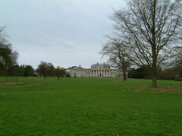
February 18th 2005 was the date of this stretch of the walk. From the car in Colton we crossed the small bridge before entering a field on the left. We then paused whilst le Coddy a eu une fuite. We set off at a brisk walk to warm up on a day which threatened rain in between sunny spells. The first part of the walk found us quickly on the tow path of the Trent and Mersey canal, which used to be the Grand Trunk Canal, walking in the direction of Stafford, which brought back memories of 1993 when myself and the family had a narrow boat holiday which took us along this part of the canal. We made excellent time because it was dry under foot and flat also. The tow path walk is nearly 4 miles long and is in lovely countryside looking over towards Cannock Chase. We were accompanied by the Trent Valley Railway on one side and the River Trent on the other. After a pleasant walk during which we could see Shugborough Hall over to our left we reached bridge 73 where we left the canal and crossed the old packhorse bridge, Essex Bridge, at Great Haywood. I have often travelled through Great Haywood by car and motor bike but didn't realise just how close it is to the bridge and Shugborough until returning by car after the walk, Pete showed me the side road off the main road which leads to the canal and Essex Bridge.
We crossed the narrow bridge and passed in front of Shugborough Hall and its impressive facade. In a short time we were on the Stafford to Rugeley Road and thence onto the Chase via the Punch Bowl car park and picnic area. Why is it called the Punch Bowl? I don't know. We paused briefly here for a bite to eat. Coddy produced a large orange and Pete suggested they shared it because he had one also which they could share later.
Onwards and upwards to the Sherbrook stepping stones. Just beyond Pierre spotted a fallow deer amongst some trees. It was well camouflaged and he did well to see it but as our eyes grew accustomed to the gloom in the trees we saw that she was part of a small herd which included two stags. One was old and limping but it had a quite large head of antlers. Coddy didn't stop to look. I don't think he's into wild life unless he was thinking about those horses on the last walk. It surprised me just how tame they were. They knew we were there a hundred yards away but took no notice. I took a photo of them.
Shortly after it started to rain a little so we parked ourselves under the shelter of a tree and ate our sandwiches. Pete then produced his orange. It was the size of a small plum! We continued and the Chase opened up a little and there were fewer trees and the rain ceased. We arrived at a trig point near to a glacial boulder. It was mainly down hill from this point, passed an area which used to be a first World War army camp, across the main A34 Cannock/Stafford road to Bednall. The total distance of this walk was 10 miles exactly and it took us 4 hours, exactly. I think we all enjoyed the walk. It was varied and full of interest all of the way.
posted by Frank Smith @ 11:00 am
0 comments
![]()
Once more into the breach. This was undertaken on Friday 4th March 2005 and once again we struck lucky once again with the weather in that it was cold but dry, once again. Because we are now nearer to home our walks are starting that much earlier. I parked my car alongside All Saints Church at Lapley and we drove to Bednall in Coddy's starting on foot at about 10 am. After about half a mile we were into the fields on the Teddesley estate and amongst names which were familiar to us Walsall lads. Teddesley Hall was built by the first Lord Hatherton, Sir Edward Littleton in the middle of the 18th century, and we have in Walsall a street named after each of those names. What the connection is with Walsall I don't know at the time of writing. The hall no longer exists but was built from the proceeds of a hoard of money found in the family home of Pillaton Hall near Cannock. £15000 went a long way in those days! The estate is now a mixed farm with sheep pastures and oak woods.
Soon enough we found ourselves moving south east on the Staffs and Worcester canal towards Penkridge a distance of 1.5 miles. Some dredging was being carried out on this stretch in readiness for the invasion of private and hired narrow boats at Easter which comes early this year. We left the canal at the Boat Inn and resisted the temptation to enter as it was still quite early, but five minutes later went in the White Hart where we had a pint of Bass I think it was. Having left there we walked north west for a short distance along the A449 and over the river Penk which is unusual in that it is one of the few north flowing rivers in England. We then turned left down a lane towards Preston Vale. It was on this section that we were pelted with hail and sleet for about 10 minutes. I hadn't got my waterproofs on and struggled to get my top out of the rucksack and put it on without stopping, this because the others won't wait for you you know. You just have to run and catch up. It had stopped by the time I had got it on. A short while later we rested for lunch. I took this opportunity to show the others my Vango storm shelter (see photo). I bought it for use in the Lakes but as I explained to them if one of them fell down and broke a leg they would be glad to shelter in it whilst waiting for help. Didn't stop them from being highly amused.
The next part of the walk took us through the hamlet of Mitton and into Bickford Meadows Nature Reserve through which you walk on raised planks of wood due to the boggy nature of the terrain. We could have done with a lot more raised planks of wood in earlier walks! This spot I'm sure would be a very pleasant place to visit later in the spring when the vegetation is a bit higher and the trees in leaf. Passing through the gently undulating countryside we were now able to see our goal in the distance, the church at Lapley. Prior to this final stretch we had been surprised at how clean we had kept our boots but the final path to the church had been churned up by the hooves of horses walking the path and we eventually arrived at the car with the usual inch or two of claggy mud on the soles. Lapley is a lovely village and it would have been very pleasant to have finished the walk with a pint in the Vaughan Arms which we have visited in the past but we didn't. Another time perhaps. The walk had taken us about four hours and 10 miles according to the GPS. Very pleasant indeed and looking forward to the next which takes us close to the West Midlands conurbation. Still you can't have everything.
posted by Frank Smith @ 11:58 am
1 comments
![]()